Back Epping Forest (District) BAR Epping Forest District CEB Ardal Epping Forest Welsh Epping Forest District German Distrito de Epping Forest Spanish Epping Forest (district) French Epping Forest (distretto) Italian 에핑포리스트구 Korean Epping Forest (district) Dutch Epping Forest (distrikt) NB
Epping Forest
Epping Forest District | |
|---|---|
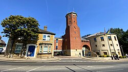
 Epping Forest District Council headquarters on Epping High Street | |
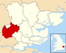
 Epping Forest District shown within Essex | |
| Sovereign state | United Kingdom |
| Constituent country | England |
| Region | East of England |
| Non-metropolitan county | Essex |
| Status | Non-metropolitan district |
| Admin HQ | Epping |
| Incorporated | 1 April 1974 |
| Government | |
| • Type | Non-metropolitan district council |
| • Body | Epping Forest District Council |
| • Leadership | Leader & Cabinet (Conservative) |
| • MPs | Eleanor Laing Alex Burghart Robert Halfon |
| Area | |
| • Total | 130.88 sq mi (338.99 km2) |
| • Rank | 106th (of 296) |
| Population (2022) | |
| • Total | 134,989 |
| • Rank | 174th (of 296) |
| • Density | 1,000/sq mi (400/km2) |
| Ethnicity (2021) | |
| • Ethnic groups | |
| Religion (2021) | |
| • Religion | List
|
| Time zone | UTC0 (GMT) |
| • Summer (DST) | UTC+1 (BST) |
| ONS code | 22UH (ONS) E07000072 (GSS) |
| OS grid reference | TL455025 |
Epping Forest District is a local government district in Essex, England. It is named after the ancient woodland of Epping Forest, a large part of which lies within the district. The district covers northeastern parts of the urban area of London, including the suburban towns of Epping, Loughton, Waltham Abbey, Chigwell, and Buckhurst Hill, as well as rural areas beyond it. The district is situated in the west of the county, bordering north-eastern Greater London.
The administrative headquarters of Epping Forest District Council are in the town of Epping. Neighbouring districts are Brentwood, Broxbourne, Chelmsford, East Hertfordshire, Enfield, Harlow, Havering, Redbridge, Uttlesford and Waltham Forest. In 2021 it had a population of 134,909.
- ^ a b UK Census (2021). "2021 Census Area Profile – Epping Forest Local Authority (E07000072)". Nomis. Office for National Statistics. Retrieved 5 January 2024.
© MMXXIII Rich X Search. We shall prevail. All rights reserved. Rich X Search